A picture containing map

AI-generated content may be incorrect.


Text

AI-generated content may be incorrect.


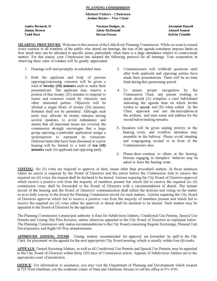
LITTLE ROCK PLANNING COMMISSION

AGENDA

MARCH 13, 2025

4:00 P.M.


I.       Roll Call and Finding of a Quorum


II.    Approval of Minutes of the March 13, 2025 Meeting of the
Little Rock Planning Commission


III.   Presentation of the Consent Agenda


IV.   Presentation of Hearing Items


V.    Citizen Communication


Map

AI-generated content may be incorrect.


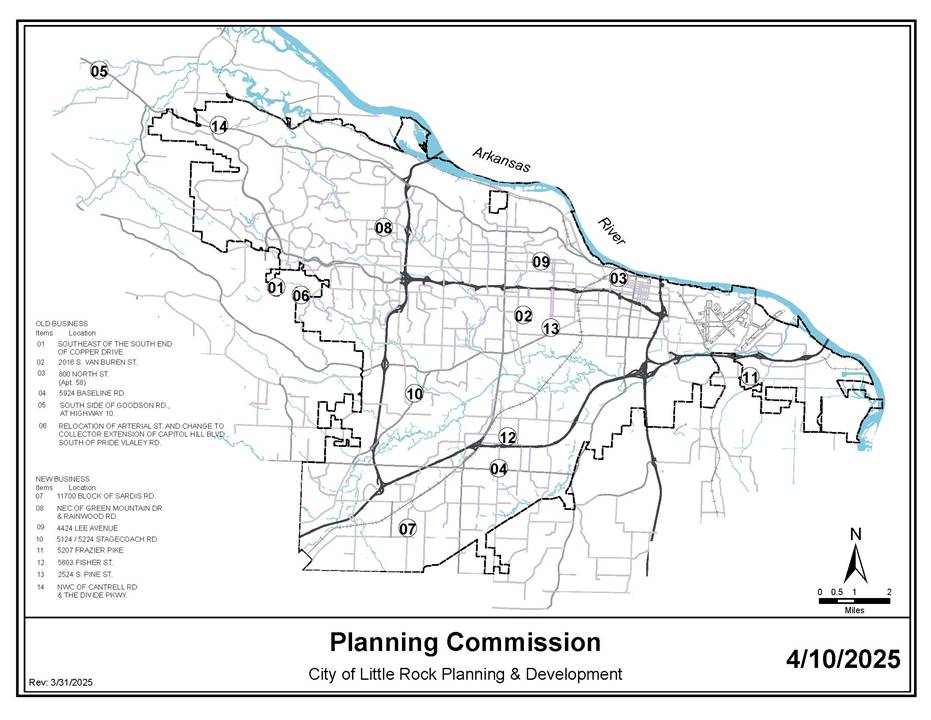
DEPARTMENT OF

PLANNING &

DEVELOPMENT


LITTLE ROCK PLANNING COMMISSION

AGENDA

APRIL 10, 2025


I.          OLD BUSINESS:


Item Number:

File Number:


Title
:


1.

S-1963

King’s Crossing Phase 1 – Preliminary Plat

Southeast of the south end of Copper Drive


·         Zoning Map

·         Sketch Map


2.

Z-10123

Gamzu Duplex – Conditional Use Permit

2016 S. Van Buren Street


·         Zoning Map

·         Sketch1 Map

·         Sketch2 Map

·         Sketch3 Map

·         Sketch4 Map


3.

Z-10107

Thornton – STR-2 – PD-C

800 North Street (Apt. 58)


·         Zoning Map

·         Land Use Map

·         Sketch Map


4.

Z-5317-B

Rezoning from R-2 to C-3

5924 Baseline Road


·         Zoning Map

·         Land Use Map


5.

Z-10132

Hoover – PD-C

South side of Goodson Road, at Highway 10


·         Zoning Map

·         Land Use Map

·         Sketch Map


6.

MSP-2025-02

Relocation of Arterial Street and Change to Collector

Extension of Capitol Hill Blvd., South of Pride Valley Road


·         Master Street Plan Map


II.         NEW BUSINESS:


Item Number:

File Number:


Title
:


7.

S-1992

Sardis Flats – Minor Subdivision Plat

11700 Block of Sardis Road


·         Zoning Map

·         Sketch Map


8.

S-1993

Berkshire Place Commercial – Replat of Lot 2

Northeast corner of Green Mountain Drive & Rainwood Road


·         Zoning Map

·         Sketch Map


9.

Z-10134

Baker Accessory Dwelling – Conditional Use Permit

4424 Lee Avenue


·         Zoning Map

·         Sketch1 Map

·         Sketch2 Map

·         Sketch3 Map


10.

Z-10010-A

Rezoning from R-2 and MF-12 to O-1

5124/5224 Stagecoach Road


·         Zoning Map

·         Land Use Map


11.

Z-10135

Rezoning from R-2 to R-4

5207 Frazier Pike


·         Zoning Map

·         Land Use Map


12.

Z-8103-A

Brewster – PCD

5603 Fisher Street


·         Zoning Map

·         Land Use Map

·         Sketch Map


13.

Z-10136

Mays – PD-R

2524 S. Pine Street


·         Zoning Map

·         Land Use Map

·         Sketch1 Map

·         Sketch2 Map


14.

Z-10143

Lots 3A & 3B, The Divide – PCD & Revised Preliminary Plat

Northwest corner of Cantrell Road & The Divide Pkwy.


·         Zoning Map

·         Land Use Map

·         Sketch Map